
Wednesday, October 15, 2014
Maryland Blue Crab Moratorium?

Friday, October 10, 2014
Potential Site for Recreational Boat Launch
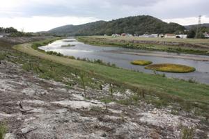 |
| Potomac River near Cumberland, MD. |
In order for this to work, a ramp would need to be constructed on top of the flood control levee so that boaters can access the river bank. This will require the permission of CSX, the U.S. Army Corps of Engineers and the Maryland Department of Natural Resources.
Park officials are currently studying the leakage problem at the Canal Basin, and think that the historic stone canal wall may need to be repointed.
Officials hope a second launch site will be added above the dam beneath the Blue Bridge.
Read the full article: Possible Boat Launch Sites Examined Along the Potomac River
Saturday, September 27, 2014
Long Bridge Reconstruction
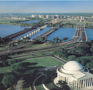 |
| Photo came from the July 1983 Metro Memo Tabloid magazine, published by WMATA* |
The Long Bridge, which runs parallel to the 14th Street Bridge, is the only direct rail connection between Washington D.C. and Virginia.
Owned by CSX, the bridge sees 56 passenger and 23 freight trains each day, which is about 98 percent capacity at peak hours. However, it is considered old and inadequate and in need to replacement.
The U.S. Department of Transportation has granted $2.8 million dollars for a National Environmental Policy Act (NEPA) study to investigate the potential for
Friday, September 26, 2014
Determining the Maryland-Virginia Border

The Potomac River has long been considered the boundary between Maryland and Virginia. However, old and new court battles have raised the questions, when the river begins to shift and expose new land does the boundary also shift.
Potomac Shores, a corporation that owns land along the Potomac in Maryland, claimed to own a 150-foot strip of land that emerged on the southern side of the Potomac River bank as the river changed course. This area, known as Potomac Wayside, was commonly used as an
Thursday, September 25, 2014
Contractor Sentenced to 10-months for Dumping National Mall Sewage in the Potomac
 |
| Potomac River at Great Falls. Retrieved from: Dcist Photo Credit: Justin Shuck |
Tuesday, September 16, 2014
Future Predictions of Flooding and Storm Surge Puts D.C. at Risk

Before sea level rise can permanently claim land its presence will be felt through higher and more frequent coastal floods caused by storm surges. Climate Central's September report, Washington, D.C. and the Surging Seas, makes predictions for potential record flooding along the Potomac River in the coming years based on local sea level rise projections of up to 4.0 feet by 2100 (based on sea level rise in 2012).
Currently, the region's record observed flood is 7.9 feet above the local high tide line. By 2100 floods exceeding today's record, up to 10 feet above the current local high tide line, may become annual events.
1,350 acres of land, $4.6 billion in property value, and 1,400 people reside less than 6 feet above the high tide line in Washington D.C. These figures increase to
Sewage Spill Leads to Cancellation of Nation's Triathlon Swimming Event
 |
| Photo Credit: MyFoxDC |
Sewage overflow into the Potomac River is not uncommon during periods of heavy rain. Early this September, such an overflow occurred releasing sewage into the river for 15 minutes. Unfortunately for the athletes of the Nation's Triathlon, it takes roughly three days for the bacteria levels from sewage overflows to dissipate, which means the swimming portion of the race had to be cancelled.
Read the Article: Sewage Spill Caused Swimming to be Dropped from Nation's Triathlon
Subscribe to:
Posts (Atom)